Vicus Laurentium Augustanorum
Located some 300 m inside the boundary of the Castelporziano estate with Castelfusano, the first recorded excavations on the Vicus took place in 1865 by the local landowner Duke Grazioli. Following the purchase of the estate by the new Kingdom of Italy in 1872 (to remain a royal preserve until 1946) the excavations were taken up again from 1874 until about 1913, during which almost the whole of three blocks and two sides of the forum square were uncovered. The work was systematic, with a railway line to carry off spoil and archaeologists from the state antiquities service on hand, such as Pietro Rosa, Antonio Pasqui, and Rodolfo Lanciani, and may have been well documented at the time. The only records yet found, however, are some photographs taken when a large black-and-white mosaic was lifted in sections and installed in the Museo Nazionale Romano in Rome in 1903-11 (it was returned to the estate in 2004). Lanciani included a short account in his popular book Wanderings in the Roman Campagna (1909) and sent two brief written reports to the London journal The Athenaeum in 1911-13; a few notes and sketches exist among his personal papers in the Istituto Nazionale di Archeologia e Storia dell'Arte in Rome and in the Vatican Library. Otherwise, the principal sources are the remains still visible on the ground, left exposed at the end of the excavations. Although buried in dense vegetation and under tree cover which has grown up over the site in the last hundred years, many walls are standing to considerable heights.
We know that one reason for the renewed interest in the site after 1874 was the discovery, in what was described at the time as a small piazza, of an inscribed marble statue base (see photo), on which W. Henzen published a detailed commentary in the Bullettino dell'Instituto di Corrispondenza Archeologica for that year. The base probably dates from the AD 160s and honoured a certain Publius Aelius Liberalis, as 'patronus' of the Vicus Laurentium Augustanor(um). Liberalis was an imperial freedman, taking his Roman family name from that of the emperor Hadrian, in whose service he was first in charge of the express postal system and then the corn supply at Ostia. Eight other inscriptions found in Castelporziano, at Ostia and elsewhere (including one at Thibursicum Bure in Africa Proconsularis, modern Tunisia) name various individuals of equestrian rank who had been decuriones and IIIIviri of a Laur(entium) vic(i) August(anorum), presumably the same place, all dateable in the later 2nd or 3rd centuries AD [for the text see 'inscriptions']. The titles would normally signify leading magistrates, in a substantial Roman town, but were sometimes used of honorific offices in professional associations (collegia), and that may be the case here. Vicus Augusti, or its variant Vicus Augustanus, translates as 'vicus of the Emperor' or 'Imperial vicus', and the word 'vicus' usually denotes a rural settlement, attached to or a dependency of a larger entity, such as a military fort or a large agricultural estate. The second epithet on Liberalis' base - Laurentium - could refer to a people or a place - people known as Laurentes, or a place called Laurentum, in either case also perhaps to be understood as qualified by the adjective 'Augustan' or Imperial. In any case, the supposition is that the site where the base was found is the Vicus in question. It is customarily refered to as Vicus Augustanus for short.
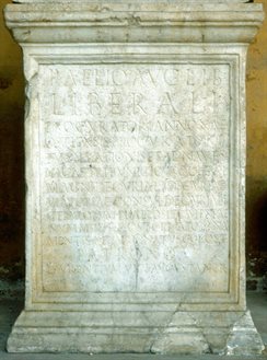 Statue base honouring P Aelius Liberalis
Rome, Terme Museum
Other places called Vicus Augusti or Augustanus are known in the Roman world, none in Italy, but several in North Africa, where they are all apparently attached to Imperial estates. One in particular, Vicus Augustorum Verecundensis, near Lambaesis (in Algeria), is interesting because it was originally called only Vicus Verecundensis, acquiring the imperial title in the early AD 160s. Similarly, the Vicus Laurentium Augustanuorum of Castelporziano could have started life as plain Vicus Laurentium - the vicus of the Laurentines - who then became the "imperial Laurentines" or " emperors' Laurentines" in the later 2nd century AD, in connection with developments taking place on an adjacent imperial estate. The huge villa at Tor Paterno, 3 kms to the south, is in all likelihood the 'Laurentum' to which the emperor Commodus withdrew when plague struck Rome in AD 191 (Herodian I, 12.2). An estate of that name had been in imperial hands since the 1st century AD, when an imperial procurator of elephants was based there (CIL VI, 8583) and may have been first acquired by Augustus, one of whose slaves was honoured with a tomb on the Via Laurentina (Gellius NA X, 2.2), perhaps taking over a property which earlier belonged to the orator Quintus Hortensius (Varro, de re Rustica III, 13.3). Archaeology has shown that the coastal villa was the focus of major re-development under the Antonine emperors, possibly during the joint reign of Marcus Aurelius and Lucius Verus (AD 161-9), who could also have invested in the Laurentine forests and their management as a hunting park. One of the other inscriptions found in the Vicus refers to a gallery of imperial portraits set up there in a building belonging to the 'saltuarii Caesaris' - the emperor's gamekeepers (see inscriptions). Who actually populated the Vicus and what went on there in the 2nd-3rd centuries AD?
A special circumstance regarding the Castelporziano vicus is the likely connection between it and one mentioned by Pliny the Younger in a famous letter of about AD 100 (Pliny, Epistulae 2, 17, 26) , in which he describes his villa on the Laurentine shore in extraordinary detail. There he says that the vicus lay just beyond the next villa, a convenient place, much closer than Ostia, to buy basic supplies or to hire a bath in the event there wasn't time to heat up the baths at home. Pliny (nephew of the more famous Elder Pliny, who perished in the eruption of Vesuvius in AD 79) was a wealthy lawyer of equestrian rank (the aristocratic order below senators) who pursued a successful political career (Praetor in AD 93 and Consul in AD 100) holding various important public and imperial offices under the emperor Trajan, and becoming a member of the imperial cabinet in AD 104-9. He was appointed governor of Bithynia (northern Turkey) in AD 110, and apparently died there in 112. Whether the vicus he knew, with its simple shops and three public baths, is all it ever was, or whether it had acquired more ambitious or specialized functions by the time it was an honour for Publius Aelius Liberalis to be its patron later in the 2nd century AD, are questions that only the detailed study of its material remains can answer.
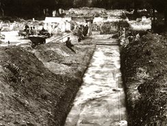 Excavation of black-and-white mosaic in building C
Modern investigations
The first modern account of the site, with a general plan and a catalogue of the epigraphic sources referring to the vicus, was published in 1973 by Gabriella Simonazzi Masarich in volume XVIII of the Monumenti Antichi of the Accademia dei Lincei. In 1983, when a general programme of archaeological research and conservation was organised by the Soprintendenza archeologica di Ostia in collaboration with the Castelporziano estate, the Vicus was among the sites singled out for particular care and attention. Its survey and documentation was allocated to the British School at Rome, which had been invited to form part of the team, on whose behalf Amanda Claridge directed a series of short annual campaigns starting in 1984.
An initial plan of the whole site at 1:100 was completed in 1986, after which the work progressed to more detailed documentation and analysis at a scale of 1:50, with some limited surface clearance to determine relative floor and street levels which had become buried under forest soil. This task was completed by 1991 and was followed in 1995-8 by two stratigraphical excavations in previously unexcavated parts of the site: one (trench X) across a street near the centre, which provided an overall chronology of occupation, the other (trench SA) across the via Severiana, which provided a substantial sample of the ancient rubbish dumps.
Varied attempts were made throughout the 1980s and 90s to plot the maximum extension of the site beyond the excavated area to east and west and to fill in some of the detail in the unexcavated areas, using geophysical and other non-invasive techniques, but, hampered by the density of the undergrowth and compromised by the quantities of debris scattered over the surface at large, the results were generally inconclusive. In 2002-7 (coinciding with a period of drought and an increase in the wildlife population which have greatly reduced the amount of low-level vegetation by natural means) new surveys were undertaken both on the western margin of the site and in the unexcavated area of the Forum, combining geophysics and high resolution contour-mapping with key-hole test excavations. This methodology has also been employed in the mapping of the zone between the Vicus and the boundary of the Castelporziano estate to the west.
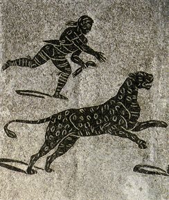 Detail of Venator and leopard from the mosaic in building C
Chronology of settlement
The excavations of 1995-8 indicate that the town was founded in the Augustan period (31 BC-AD 14), probably around 10-5 BC. Most of its earliest structures were very lightly built, some on footings of oyster shells, laid on sand, with elevations probably in wood and reed. These were replaced in tufa and/or brick-faced concrete after the middle of the first century AD, and underwent numerous alterations and rebuildings thereafter, especially in the second and third centuries. The settlement was still thriving, at least in pockets, during the fourth century, but was apparently abandoned quite abruptly in the early fifth century (c. AD 420). Its latest phase of occupation coincides with the systematic spoliation of marble and other building materials, interleaved with thick deposits of wind-blown sand, suggesting that climatic changes affecting the nature of the shoreline in this particular region may have been a contributing factor. There are indications of sea-front changes in earlier periods, too. In the course of the first and second centuries AD not only were the street system and many of the initial buildings remodelled or replaced, the ground level was artificially raised and the settlement itself expanded in the direction of the sea: new buildings of the second century AD were extended some 50-80 metres forward of their predecessors, and where the earlier buildings had been raised on vaulted concrete substructures, the later ones were at least in part raised on sand.
Layout and composition
The first modern account of the site, with a general plan and a catalogue of the epigraphic sources referring to the vicus, was published in 1973 by Gabriella Simonazzi Masarich in volume XVIII of the Monumenti Antichi of the Accademia dei Lincei. In 1983, when a general programme of archaeological research and conservation was organised by the Soprintendenza archeologica di Ostia in collaboration with the Castelporziano estate, the Vicus was among the sites singled out for particular care and attention. Its survey and documentation was allocated to the British School at Rome, which had been invited to form part of the team, on whose behalf Amanda Claridge directed a series of short annual campaigns starting in 1984.
An initial plan of the whole site at 1:100 was completed in 1986, after which the work progressed to more detailed documentation and analysis at a scale of 1:50, with some limited surface clearance to determine relative floor and street levels which had become buried under forest soil. This task was completed by 1991 and was followed in 1995-8 by two stratigraphical excavations in previously unexcavated parts of the site: one (trench X) across a street near the centre, which provided an overall chronology of occupation, the other (trench SA) across the via Severiana, which provided a substantial sample of the ancient rubbish dumps.
Varied attempts were made throughout the 1980s and 90s to plot the maximum extension of the site beyond the excavated area to east and west and to fill in some of the detail in the unexcavated areas, using geophysical and other non-invasive techniques, but, hampered by the density of the undergrowth and compromised by the quantities of debris scattered over the surface at large, the results were generally inconclusive. In 2002-7 (coinciding with a period of drought and an increase in the wildlife population which have greatly reduced the amount of low-level vegetation by natural means) new surveys were undertaken both on the western margin of the site and in the unexcavated area of the Forum, combining geophysics and high resolution contour-mapping with key-hole test excavations. This methodology has also been employed in the mapping of the zone between the Vicus and the boundary of the Castelporziano estate to the west.
 Vicus Augustanus
Axonometric reconstruction
by Sheila Gibson (1996)
with modifications 2007
Clickable plan of Vicus Augustanus
|
|
|
|
The largest (A), dated by numerous brickstamps in its drains to AD 200, was probably a benefaction from the emperor Septimus Severus. In the 4th century AD it was reduced to a fifth of its original size. A second, smaller set (Z) on the other side of the forum has only been explored in part, but probably dates from the mid 2nd century AD. Another two (C 54-66 and F 29-41+ E), of similar date, may have been more private facilities, associated with the properties to which they are attached. The baths in C underwent numerous alterations and in their last phase (3rd-4th centuries AD) may have functioned as an independent establishment.
|